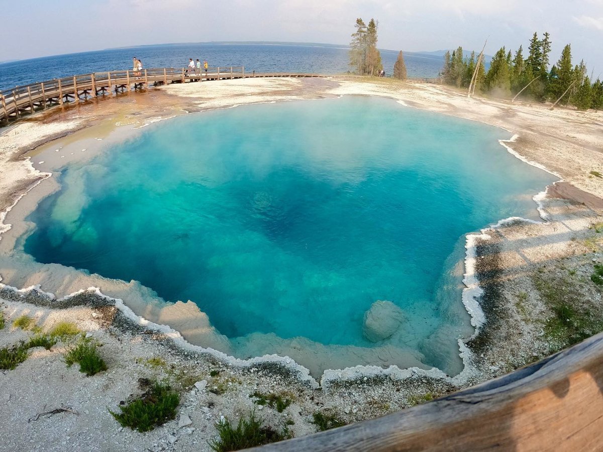
Very Easy: West Thumb Geyser Basin
- Location: Yellowstone National Park
- Trail type: Boardwalk
- Duration: 30–60 minutes
- Distance: 0.6 to 1 mile
West Thumb Geyser Basin sits on the shore of Yellowstone Lake, the largest high-elevation lake in North America. The boardwalk winds past colorful hot springs, mud pots and lakeshore geysers, including the bubbling Thumb Paint Pots and nearby Twin Geyser, with open water views along the way.
This paved boardwalk loop is a short, very easy route that works well for families, strollers and many wheelchair users. Visitors can reach the Thumb Paint Pots and Twin Geyser without assistance. The lower loop includes a steeper section, which may require assistance for some wheelchair users. To help preserve the area’s delicate terrain and enjoy the route safely, stay on the designated boardwalk at all times.
Easy: Tower Trail
- Location: Devils Tower National Monument
- Trail type: Paved loop (Tower Trail)
- Duration: 45–60 minutes
- Distance: 1.3 miles (Tower Trail)
Devils Tower National Monument rises 867 feet above the surrounding plains of northeast Wyoming, a striking column of rock unlike anything else in the country. The 1.8-mile Tower Trail encircles the monument's base on a paved loop, offering 360-degree views of the monument and the surrounding Ponderosa pine forest.
The first 0.2 miles of the Tower Trail are wheelchair accessible. Beyond that point, the route becomes steeper and is not recommended for wheelchair users. Visitors with hearing impairments will find illustrated wayside exhibits and publications at the visitor center, and large-print and braille brochures are available for visitors with vision impairments.
WY Responsibly Tip: Devils Tower has been a sacred site for Northern Plains tribes, including the Kiowa Tribe, for thousands of years, and remains culturally significant for the Eastern Shoshone and Northern Arapaho peoples today. Be mindful that this is an active cultural landmark, not only a hiking destination.
Very Easy: Bear River State Park
- Location: Evanston
- Trail type: Paved & Packed Gravel
- Duration: 30–60 minutes (Bear River State Park Loop)
- Distance: 2.7 miles (Bear River State Park Loop)
Just outside Evanston, Bear River State Park is a 324-acre day-use park with an easy loop trail and nearly three miles of paths along the Bear River, including 1.2 miles of paved path and 1.7 miles of packed gravel on the west side of the river.
The paved and packed-gravel paths are wheelchair-accessible, making Bear River State Park an excellent choice for an easy day outdoors. Surfaces may vary slightly by section, so visitors using mobility devices may want to check current park conditions before heading out.
WY Responsibly Tip: Bear River State Park is home to herds of bison and elk, including a rare white bison born at the park in 2023. The birth of a white bison is a 1-in-10-million event that holds sacred meaning for some Indigenous communities. To protect these remarkable animals and keep your visit safe, view wildlife from a safe distance, stay on designated trails and give them plenty of room to roam.
Easy: Sinks Canyon State Park
- Location: Lander
- Trail type: Dirt & Paved (Mixed)
- Duration: 30–60 minutes (Sink to Rise Trail)
- Distance: 1.4 miles one-way (Sink to Rise Trail)
At Sinks Canyon State Park, the Popo Agie River flows into a limestone cavern and disappears at a natural feature known as The Sink. A quarter mile down the canyon, it resurfaces at a spring called The Rise, having traveled underground through a series of tunnels and channels.
There are a few easy ways to see both The Sink and The Rise. An observation deck behind the visitor center offers a view of The Sink without taking the trail down, while the paved, ADA-accessible Sink to Rise nature trail leads from the parking lot to The Rise.
The fully accessible visitor center adds helpful context with exhibits on the canyon’s geology, wildlife and history. Visitors will also find accessible fishing areas and wheelchair-friendly options for three of the park’s four yurts, making Sinks Canyon State Park a great choice for an easy, rewarding outdoor experience.
Easy: Medicine Wheel Passage
- Location: Bighorn National Forest
- Trail type: Gravel and Dirt Road
- Duration: 1 to 1.5 Hours (Medicine Wheel Trail)
- Distance: About 3.0 miles round-trip (Medicine Wheel Trail)
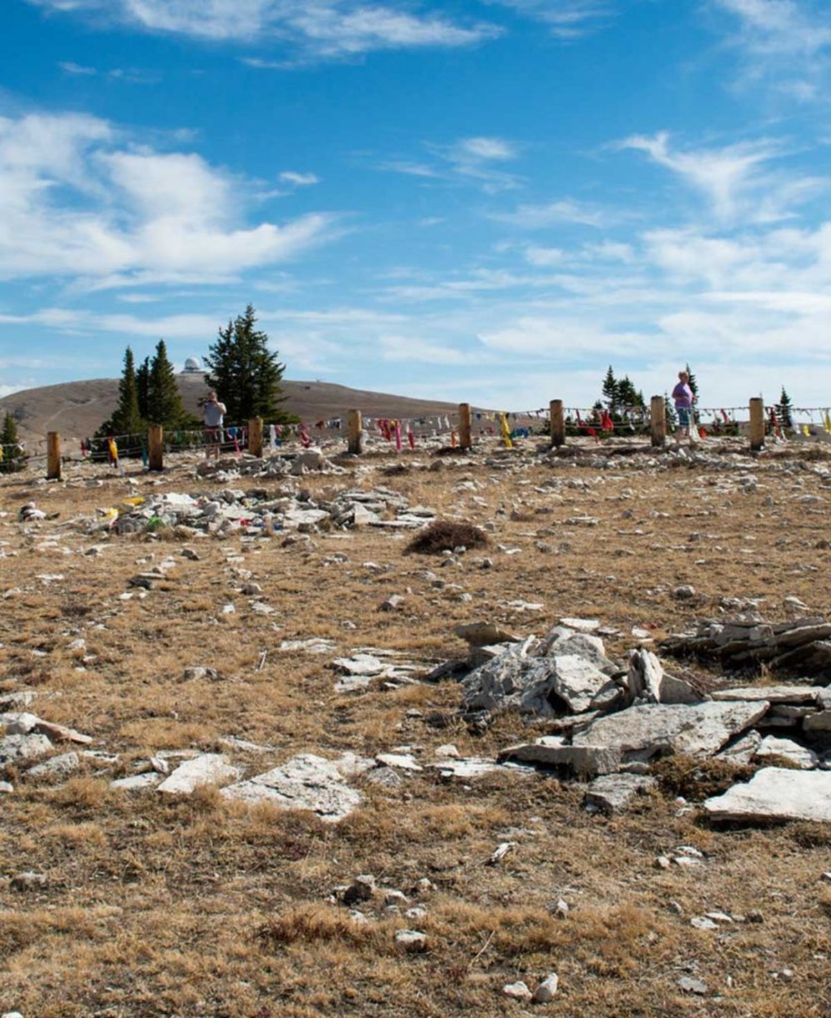
The Medicine Wheel is an ancient Indigenous stone monument, roughly 80 feet in diameter, constructed on a high ridge in the Bighorn Mountains and used for spiritual and ceremonial purposes for thousands of years. It sits at 9,430 feet, with views dropping thousands of feet into the Bighorn Basin along the way.
To reach the Medicine Wheel, most visitors follow the Medicine Wheel Trail — a 1.5-mile gravel road from the main parking area to the site, making the full trip three miles round trip. Visitors with different abilities can request permission to drive their own vehicle to a smaller parking area near the Medicine Wheel.
WY Responsibly Tip: The Medicine Wheel is a sacred Indigenous site where ceremonial activity continues today. If a ceremony or spiritual practice is taking place, do not take photographs. Never touch, move or photograph sacred prayer offerings, such as cloth or tobacco ties, left on the perimeter fence or inside the wheel.
Tips for Hiking Responsibly in Wyoming
Even the easiest Wyoming trails are best enjoyed with a little preparation. Here's how to hike responsibly and make the most of your time in the Cowboy State.
Plan Before You Go: Check trail conditions, park alerts and weather forecasts before you head out. Always let someone know your plans and expected return time. Pack water, snacks, sunscreen, a first-aid kit, a map or GPS, layers and sturdy shoes. Mountain weather in Wyoming moves fast and carrying backup supplies in case your hike runs longer than planned is always a good idea.
Leave No Trace: Pack out everything you bring in, including pet waste. The goal is to leave every trail exactly as you found it, or better. Learn more about how to WY Responsibility here.
Respect Wildlife: Give animals plenty of space. Do not approach, chase or feed animals and give them plenty of room to roam: 100 yards from bears and wolves, and 25 yards from all other wildlife. For the best chance to view wildlife safely and responsibly, consider booking a guided tour.
Stay on Marked Trails: Staying on designated paths protects the delicate ecosystems these trails pass through. Yield to uphill hikers and horseback riders, and respect all guidelines for the land you're on.
Ready to Explore Wyoming’s Trails?
In the Wild West, hiking trails span far and wide, from the geothermal shores of Yellowstone Lake to the high ridges of the Bighorn Mountains and the canyon parks of central Wyoming. Browse our Wyoming hiking trails and start planning your adventure in the Cowboy State.