Wilkins Peak Trail System
Green River | Salt to Stone
WILKINS PEAK TRAIL SYSTEM
Named the most popular trail system in the state, Wilkins Peak Trail System offers single track trails for riders of every skill level. Fourteen trails and more than 20 miles of varied terrain and features including switchbacks, bridges and drops will challenge even the most advanced riders – it’s what keeps mountain bike enthusiasts coming back again and again.
Channel Surfing Trail
For a beginner-level trail with beautiful views of the city of Green River and natural bluffs, ride the Channel Surfing trail. This 1.66-mile trail follows along the Green River and features minimal elevation gain and softer, sandier terrain in some areas due to its proximity to the river.
Brent and Mikes Trail
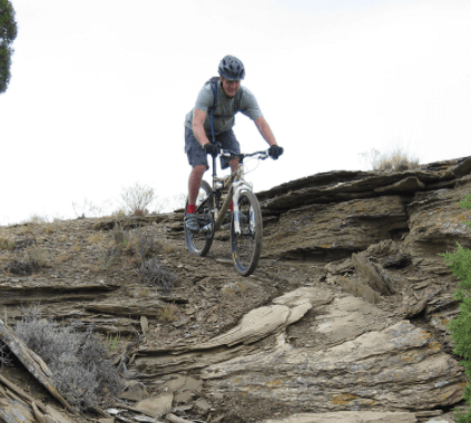
The intermediate rider will not want to miss this adventurous six-mile loop trail featuring bridges, ladders, berms and drops. Alternate routes around each feature make this desert ride accessible to more novice riders as well. The Brent and Mikes trail links to many other trails in the Wilkins Peak Trail System including TNT, Quickdraw and Cruiser.
Pick Your Poison Trail
For a fun and challenging trail with obstacles and technical features, advanced riders will want to ride the Pick Your Poison trail. This five-mile trail starts from the Brent and Mikes trail and ends at the Cruiser trail. Expect tight switchbacks, steep climbs and many other natural features on this scenic trail.
Find it: From The Bike and Trike, travel west on I-80. Take exit 91 to continue on E Flaming Gorge Way in Green River. Turn right on Uinta Drive and then left on W Astle Avenue. Continue on to Mountain Fuel Station Road which turns right into E Teton Boulevard. Turn left off of E Teton just north of Jackson Elementary School and cross the river bridge. This road travels to the right where you will see a parking area next to the outdoor archery range. Park here for a longer ride or to access the beginner trails such as Channel Surfing.
There is a second parking area and Info Kiosk 0.5 miles farther down the road. This is the trailhead for intermediate and advanced trails, Fast Exit, Draino and Don’t Chute. From here you can ride to the Brent & Mikes trail or drive another two miles to the trailhead
Learn more about Salt to Stone
Much More to Explore
There are many ways to get out and explore all that Wyoming has to offer. Explore things to do and places to go and make your Wyoming vacation one to remember forever.